Yesterday (Saturday, August 24) I participated for the first time in D2R2, the Deerfield Dirt Road Randonnée. D2R2 is a cycling event exploring the dirt roads of Franklin County, Massachusetts, and southern Windham County, Vermont. There are several versions of the ride: 100K, 115K, 150K, and 180K. What characterizes them all is that they are extremely difficult for the distances involved. Dirt roads in this area generally rise from the river valleys, whose roads are paved, up into the hills. Some of them barely count as improved roads (Old Albany Road, Hawks Road, and stretches of Franklin Hill Road, I’m thinking of you). They are often quite steep and generally eschew switchbacks. The ride designer, Sandy Whittlesey, had this to say about the course. The organizers, the Franklin Land Trust, also offer a 40-mile Green River Tour for cyclists who want to see some of the area’s natural beauty while avoiding strenuous climbs.
I had initially signed up for the 115K course, which has around 9,000 feet of climbing, but a few weeks before the event I did a frank assessment of my preparation and decided to switch to the 100K. D2R2 organizers are cool with switching, even the day of the event; some riders mix and match parts of the rides, which all converge on the Green River Covered Bridge in Guilford, Vt. (The 150K has its first rest stop there; for the other rides, it’s the lunch site.) With “only” 7,800 feet of climbing, the 100K seemed more my style. An additional advantage was that the 100K started an hour later than the 115K, at 9 am; since Jennifer kindly agreed to drop me off at the start, that let us both get a little more sleep.
This is a long post. The brief version: it was a great ride, challenging but not draining, on a beautiful day through gorgeous countryside. The event was carefully organized and the volunteers were cheerful and efficient. I’ll be back! If you want to skip my narrative, you can jump to my post-ride reflections.
The day of the ride
The weather was gorgeous: clear skies, low humidity, cool in the morning, and little wind. It was in the low 60s F at the starting point in Deerfield, with highs forecast for the 70s. Hard to imagine better cycling weather! I had prepared my bike and gear the night before: tires inflated, brakes checked, chain lubed, bottles filled, tools and spare parts packed, and some emergency food ready. (Since the ride literally did not pass a single food or convenience store, the checkpoints provided food, but I wanted to be prepared in case I needed more or had a breakdown.) I had a light breakfast, a slice of toast and coffee.
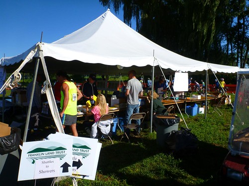
Jennifer dropped me off at the starting point, a big field south of Historic Deerfield, around 8:30. I set up my bike, picked up my registration packet, attached my ride number and electronic chip to my jersey and helmet, and grabbed a bagel and some cream cheese for breakfast #2, along with a cup of hot water to take off a bit of the chill; I was wearing a lightweight, short-sleeved wool jersey, but figured that I’d warm up once the ride started. I milled around a bit, admiring some of the bikes; others, in turn, admired my Boulder All Road.
In the ride report below, I’m indicating distances and climbing based on what my GPS read. They differ somewhat from the cue sheets provided by the organizers, which claimed 62.7 miles and 7800 feet of total climbing.
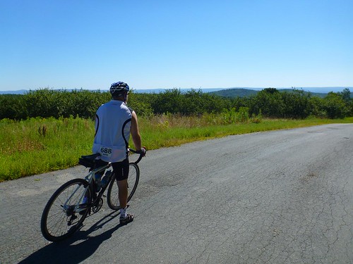
From Deerfield to the Little Big House: 13.3 miles, 2126 feet of climbing
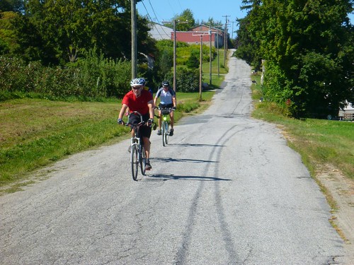
At exactly 9 am, I started my computer/GPS and rolled through the starting gate. D2R2 isn’t finicky about starts; some riders started earlier, others later. The gate computer should have read my electronic chip, though I don’t recall hearing it beep. We turned south along Mill Village Road. I was riding along with a couple of others, Barry from Worcester and Patrick from Franklin, MA. Patrick had a helmet camera that took a picture every 30 seconds. He was planning to edit the ride down to a slide show, though he admitted that looking at someone’s ride record was even worse than watching vacation slides.
[2013-08-27: The narrative has been corrected in light of Patrick’s comment, below. I had originally identified the rider with the helmet cam to whom I spoke as being from New York City; I misremembered.]
At the first short hill, Patrick powered on ahead of us. Barry and I held back, not wanting to wear ourselves out prematurely. He and I would end up riding together all day. I had the cue sheet on the top of my handlebar bag, and I had programmed the course into my GPS. He was happy to have someone to navigate; I was happy to have someone to ride with who was interested in going about the same speed. It was great riding together.
A little further on we passed a knot of riders who had stopped. It looked as if there had been a minor crash. I heard someone say later that it was caused by a dropped pair of sunglasses, but I didn’t get the details. We soon passed Clarkdale Orchards and turned left onto Old Albany Road for the first serious climb of the day. “Road” was a misnomer; it looked like someone’s poorly maintained gravel driveway. In fact, a couple riders mistook the first driveway we encountered for the road. I averaged 6.5 mph for the 2 miles we climbed, mostly on dirt with plenty of loose rocks and sand. I had to put my foot down at one point where I lost traction on the rear wheel, and walk my bike a yard or so forward to a spot with firmer dirt.
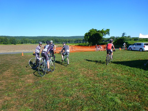
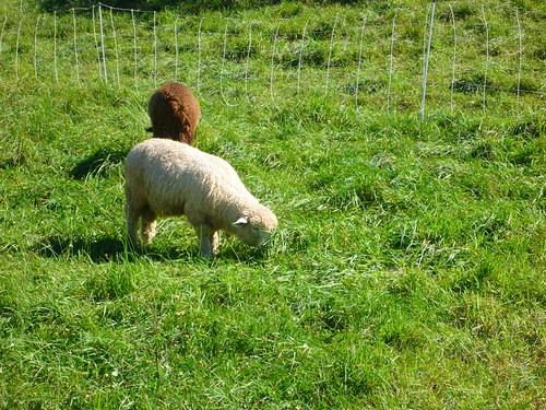
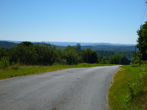
After that, we had rollers on mostly paved roads until we reached Route 2. From there, it was a long climb up a mixture of dirt and pavement until we reached the first checkpoint. We passed grazing sheep and gorgeous views.
There was a little respite when the road turned down, but then it climbed back up toward the first rest stop of the day.
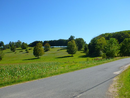
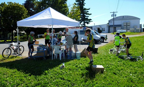
I arrived at Little Big House happy with how the day was going. The segment with the most climbing per mile was out of the way. My low gear was sufficient, though there were times I would have liked something even lower; I came to envy the mountain bikers with their 22/34 low gears. My heart rate had gotten a little high on some of the climbs, but I didn’t feel as if I had exhausted myself prematurely. My legs didn’t feel great, but they were still turning the pedals. I refilled my water, added a little Gatorade powder to one bottle, and chowed down on a slice of watermelon. The volunteers were cheery and efficient, and everyone seemed to be having a grand time. A photographer snapped a few photos of my bike, including a detail of the Honjo hammered fenders.

From the Little Big House to the Green River Covered Bridge: 23.9 miles, 2425 feet of climbing
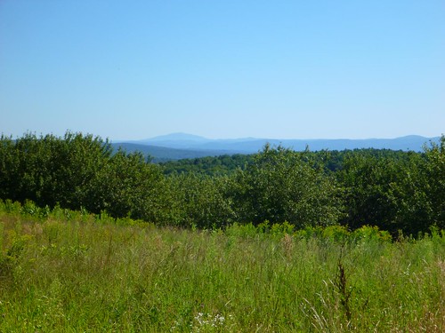
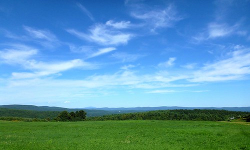
As we left, we encountered more gorgeous views looking east toward Mount Monadnock. For five miles we had rollers, trending downwards but with just enough up to keep us working. I noticed that I was slowing down on the upward bits and using my lowest gears even on relatively moderate grades.
A photographer in a car—the one who had taken a few photos of my bike at the rest stop—took a few pictures as we climbed the steep grade of Prolovich Road; then her driver pulled ahead of each of us in turn, snapping photos of our effort. She told me not to look at the camera, but to look down at the dirt as if I were struggling to keep going on. I laughed and said I was struggling, but I was having too much fun not to smile! I did grimace obligingly before she left.
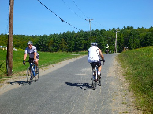
Then there was a thrilling 1.25 mile descent into Colrain; I was annoyed by a rider ahead of me who was going a lot more slowly than I, with auto traffic making it impossible to pass. I ended up having to alternate front and rear brakes to slow to his speed. We rode a little more than 3 miles on Route 112, where a large group of motorcyclists passed us a little too closely while revving their engines to produce a gratuitous noise. I don’t know why some motorcyclists feel compelled to do that to bicyclists.
Then another steep dirt climb that took us out of Massachusetts and into Halifax, Vermont. I stopped to answer the call of nature, waving Barry ahead; it would be another 20 minutes or more before I caught up to him. I paused again at a water bottle drop to refill the nearly empty bottle and mix in a little more Gatorade. We passed from sun-dappled forests to beautiful meadows. After another downhill, we started the long climb up to Halifax Center, then County Road past the summer home of a high school friend’s in-laws (they were elsewhere this weekend, so I couldn’t stop by for a brief chat), and finally, after a brief respite, Deer Park Road. By this point I was routinely dropping down into the lowest gear whenever the grade got serious; fatigue had definitely replaced cardiovascular fitness as the limiting factor on my performance.
The reward after we passed the top was a thrilling, occasionally scary descent on bumpy gravel. At one sharp corner, organizers had arranged for EMTs to be posted, and there were several radio relayers on the course, much of which was out of cell phone coverage. I took a hand off the bars to wave to the EMTs and nearly took the corner too widely, which would have been ignominious. Here and there we saw water bottles that had bounced out of bottle cages or riders’ pockets.
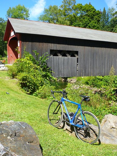
The bumps got to my bike too. As we reached the gentler grades next to a river, I noticed that my bike was making a rattle, and Barry said he could see the fender vibrating. Sure enough, both of the bolts securing the fender stays to the dropouts had worked loose. After a few minutes I had them adjusted, not perfectly but well enough to finish the ride. We continued down along the river, arriving at the Green River Covered Bridge, the lunch stop, at about 12:40 pm.
There were bikes everywhere: propped up on the railings next to the bridge, laid on their sides on the grass, propped up against trees…. There were cyclists everywhere, too; for around 900 riders on the 180K, 115K, 100K, and the 40-mile Green River Tour, this was the place for lunch.

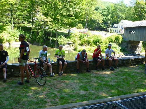
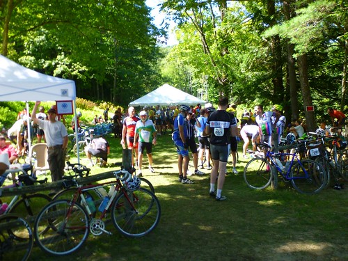
Despite my tired legs, and some lower back pain on the tough climbs, I was feeling pretty good. I verified that the fender was well enough adjusted to survive the rest of the ride, and then I headed for the food. A turkey sandwich, a bag of chips, and some Gatorade later, I was feeling fine. I did have to queue for at least 10 minutes, maybe more, to use the porta-potty; one of the volunteers mentioned that they should get more the next time. As far as I’m concerned, that was the only minor problem with the entire operation. Again, the volunteers were cheerily working their butts off, and the mood was joyous and festive.
Update, 8/26: Robert Kerner, one of the other riders, took this picture at the lunch site; I’m in the center, bending over to check my front tire pressure:

Photo copyright © 2013 Robert Kerner; linked to Flickr
From the bridge to Apex Orchards: 15.4 miles, 1216 feet of climbing
After a 40-minute lunch break, Barry and I were both ready to continue. We had 10 miles cycling gently downhill along the Green River, first on dirt and then on pavement. My highest average speed of the whole ride was here. The idyll ended when we made a hairpin turn heading up the hill: back to grinding uphill on dirt. One long climb was succeeded by a thrilling downhill on mixed pavement and dirt, and then a shorter but steeper climb brought us up to the aptly named Apex Orchards, where again we had a stunning view to the east.

Most riders had peaches. I had pickles. And a last water bottle refill. As we thanked the volunteers for being there, they thanked us: one of them said, “Without you, we wouldn’t be here.” True—but then, they wouldn’t need to be there! I gave Jennifer a call to let her know I would be in Deerfield in just over an hour; she was on her own ride up to Leverett and Shutesbury, so I left a voicemail.
From Apex Orchards to Deerfield: 12.4 miles, 858 feet of climbing
The last fifth of the ride seemed longer than it should. We had a downhill stretch that brought us briefly to Route 2, then another climb. Barry’s front derailleur was shifting worse and worse. After another bumpy descent on gravel, we returned to Route 2. By that point, his front derailleur wasn’t shifting down into the small ring at all: a clear problem given the climbing that remained. We figured out that his inner limit screw had vibrated in, preventing the derailleur from shifting far enough to the left. A half turn of the screw fixed the problem and we continued, down Zerah Fiske Road and then up Lucy Fiske Road. We had a brief roller on pavement, then a nice descent on Taylor Road to the fork with Hawks Road.
Hawks Road is infamous among D2R2 riders. It descends on pavement, then climbs on increasingly narrow, rocky dirt, before descending for a mile along a twisty route with lots of rocks and washed-out areas. We saw the photograher from Little Big House and Provolich Road for a third time. We also passed one cyclist who seemed to be dealing with a flat, but it was too steep and treacherous for small talk. After watching me swaying around more than I should, Barry gave me some tips from his mountain-biking days about putting more weight on the bike. Despite my caution I might have beat my previous time down this road, but for the fact that my downtube water bottle cage had loosened up! I thought it had been pretty tight, but maybe I’ll use threadlock before my next gravel road ride. It didn’t take long to tighten the screws, but as I worked on it, a couple riders, probably thinking I was daunted by the hill ahead, told me it was the last one! To be fair, I wasn’t exactly looking forward to climbing it, even though I had done so two weeks before and knew what to expect.
After Hawks Road, it was an easy three miles back to the start/finish line. I crossed the line, heard a beep, and stopped my computer. My ride was over. I was tired, my back was sore, and my knees had been twinging on the last few climbs. I could have kept on riding for a while, but I decided to forego the optional concluding loop through Historic Deerfield.
After the ride
Barry was heading back to his car, at the camping area, to put away his bike, and then he was going to catch a shuttle to the showers, so we said our farewells. As I was trying to find the check-in for riders, someone saw my bike and introduced me to Mike Kone, of Boulder Bicycle and René Herse Bicycles; I thanked him for his guidance and help ordering and assembling my bike, and we paused for a photo.

Unfortunately, after meeting Mike, and being generally befuddled, the check-in slipped my mind. I went to prop up my bike and call Jennifer to follow up on my voicemail. She answered, saying she had just parked the car when her phone rang. We met up, I put my bike and gear in the car, and then we went for some food; I had bought an extra meal ticket for her, and she hadn’t eaten since her own bike ride. Food was copious and pretty good; we had pulled pork, a biscuit, a salad, and cupcakes. Mine was washed down with a glass of the Berkshire Brewing Company’s Preservation Ale!
Then we headed home. On our way out of the parking lot we saw an ambulance and police cruiser, lights flashing, near the finish line; a minute later a Northampton Fire Department ambulance rolled up. I hope that it wasn’t for anything serious.
When we got home and I took my ride number bib off my jersey, it struck me that I had never checked in at the arrival. Oops! I felt like an idiot for being so easily distracted. I didn’t want the organizers to worry, especially since I hadn’t left a car in the lot, so I fired off a quick email to the two contact people to let them know. I hoped at least one would be checking email, since I couldn’t find a ride day contact phone number. Fortunately, Mary Lynn got the message minutes after I sent it.
Post-ride reflections
As this was my first D2R2, I didn’t know what to expect. Other than suffering; that much was clear from the ride reports I had read online, and the way everyone talked about the ride. I know most of the reports are about the 180K; I’m not that strong a rider—yet—and the 100K doesn’t have anything close to Archambo Road, with its 28% wall. But it was tough. I’m satisfied to have completed the ride, and to have done so in just over 6 hours of actual riding time.
The Franklin Land Trust and volunteers did an excellent job organizing the event. My hat is off to them. Over a thousand cyclists participated in this year’s D2R2. Pre-event communication was very helpful. The registration and food areas looked a little chaotic when I arrived, but that was simply because of all the cyclists milling about. The event staff had everything down cold. Picking up my registration material and T-shirt were a cinch, as was finding a little pre-event food. At the checkpoints, everyone was smiling and efficient. I might suggest a couple extra porta-potties at the Green River checkpoint. And it would be helpful to have a phone number to contact an on-site organizer on the day of the event, so that boneheaded folks like me who forget to check in at the end can call up; a Google Voice number could be set up to forward calls to one or two organizers’ cell phones.
The roads themselves were beautiful. The light and temperature helped: it was cool riding through forests, with many small brooks running alongside them, then amazing to burst out into a meadow and see a distant ridge or mountain. There was the occasional car, especially on the short stretch of Route 112 and on Green River Road, but they were few and far between. I know that’s true of many back country roads around here; as a local, I’ve been able to ride many of them. But these were pretty darn good even by comparison with our usual lot.
Finally, being surrounded by so many cyclists in good spirits, clearly having a good time as they challenged themselves, was exhilarating. I’m used to cycling alone or with Jennifer. I don’t think I would want such camaraderie on every ride; I’m too much of an introvert. But once or twice a year, it’s not bad. I’ll be back—if not next year, then soon.
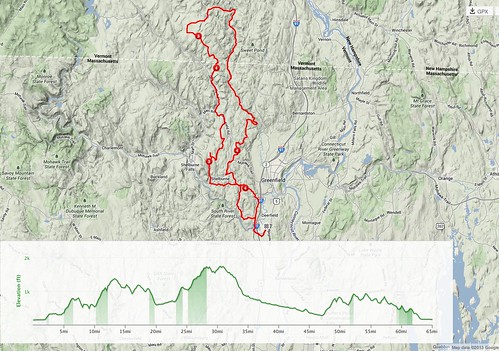
Statistics, map, and elevation profile
Distance: 65.1 mi/104.8 km
Elevation gain: 6631 feet/2021 m (per my GPS; TrainingPeaks claimed 7420, and the organizers, 7800)
Moving time: 06:04:17
Elapsed time: 07:22:50
Average moving speed: 10.7 mph/17.2 km
Average speed including rests and lunch: 8.8 mph/14.2 kmh
Maximum speed: 40 mph/64.4 kmh
Average cadence: 70
Calories burned: 3228 (per Garmin Edge 800)
Calories consumed before ride: 519
Calories consumed during ride: 852
Hi Brian- I was spending time yesterday processing my thoughts and memories about the 100k, searching for ride reports like yours, and uploading my time-lapse pictures from the day. I spotted this shot from the first few miles of the ride, and recognized your bike, so I bet I am the rider you remember with the helmet cam, although I am from Franklin MA rather than NYC.
http://img.photobucket.com/albums/v149/Pattio/FILE0763copy_zpsa8884648.jpg
The helmet cam battery only lasted until the Green River Bridge lunch stop, but that still amounted to several hundred pictures, including me trying to get my chain out of my spokes when I overshifted going for my granny gear on the first difficult climb!
Thanks for sharing your pictures and writeup, and I hope we will chat again, however briefly, at another wonderful D2R2 next year!
— Patrick · Aug 27, 08:11 AM · #
Hi Patrick – thanks for posting, and for your correction! I must have been talking to someone from NYC just before we chatted. It’s hard to take notes when riding! I’ll correct the post.
I’m glad you had a good ride!
— Brian Ogilvie · Aug 27, 09:12 AM · #
Excellent write-up. I love all the photos as well. D2R2 remains on my mind quite a bit still, and it is great to read different accounts of the experience like yours. I am so glad I did it, and look forward to next year.
— Tim Cary · Sep 5, 11:30 PM · #
You are right, at least in my opinion, that the 100K is hard even though it doesn’t have some of the walls on the 180k. At least this was true in the 2009 edition of the 100K. This year we did the Green River Tour, which isn’t quite part of the D2R2 – not much climbing but a decent percentage of the ride was on dirt.
I checked your bike and said hello. You checked out my companion’s JBryant while were looking at your Boulder.
— Daniel · Sep 16, 11:16 PM · #